Current Issues
Current issues affecting bicycling in Brookline include:
Proposal to rebuild Washington Street from Brookline Village to Beacon Street. Please consider signing a petition supporting the creation of protected bicycle lanes along Washington Street.
Upcoming reconfiguration of Brookline Avenue from Washington Street/Route 9 to the Boston border
Proposed Beacon Street Bridleway Path
Increasing funding for the Transportation Division to enable the hiring of a sustainable transportation professional and the acquisition of quick build materials. Please consider signing a petition asking the Select Board to raise parking meter rates to adequately fund the Town’s safe streets and sustainable transportation initiatives.
Bicycle access plans for the Pierce School Redesign. Please consider signing a petition asking the Town to do a serious study of closing School Street to create a Pierce Green to connect the playground to the school campus and town center.
Brookline High School Bicycle Access
Adequacy and quality of bicycle parking
Two-way protected bike path on Chestnut Street between Kendall Street and Walnut Street
Proposal to improve bicycle accessibility from South Brookline to the Brookline High School.
Proposed safety improvements on the Boston University Bridge
Read more about each of these issues below.

Washington Street Complete Streets Project
The Town has applied for federal and state funding to rebuild Washington Street from Station Street in Brookline Village to Beacon Street. Please sign this petition circulated by Biking Brookline supporting the creation of protected bicycle lanes along Washington Street as part of this project. More information is available at WashingtonStBrookline.com.
Washington Street is a critical artery that connects Driscoll School, Pierce School, the Main Library, Town Hall, the Public Safety Building, and two commercial districts. It is immediately connected to Brookline High School by Greenough Street. At present, the only bicycle accommodations on Washington Street are unprotected painted bike lanes in some areas and sharrows in others.
The Washington Street project will be subject to the Town’s Complete Streets Policy, which will require that the rebuild provide safe and comfortable access for healthful and sustainable transportation choices such as walking, bicycling, and mass transit.
In 2022 the Transportation Board approved new interim pavement markings between Gardner and a point just short of Cypress, to be completed as part of the current pavement preservation project.
These new pavement markings include:
Improving the bike path on the north side of Washington Street between Gardner and a point just short of Cypress by creating a buffer between the bike lane and the parked cars.
Creating a new curbside bike lane on the south side of Washington Street on that same stretch. The lane is buffered between Gardner and Park.
Improving safety by using green pavement markings for the new and existing bike lanes between Beacon and Cypress where they cross intersections.
Creating a bike turning box at Park.
The Design Review Committee has held numerous meetings since its formation in 2022. The proposed conceptual design for the rebuild of Washington Street from Beacon Street to Cypress Street provides for protected bicycle lanes along the corridor. The plan would also reduce curbside parking along the corridor.
In response to concerns expressed by merchants and representatives of the disabled community about the loss of parking, the Town’s consultant re-assessed how many parking spaces could be preserved while also having the protected bike lanes and presented this revised conceptual design to the Select Board on April 2, 2024, the Small Business Development Committee on May 14, 2024, and the Design Review Committee on May 22, 2024. The revised conceptual design would preserve 58% of the existing parking spaces on Washington Street between Beacon and Cypress streets, and 60% of the parking spaces on Washington Street between Cypress and Station streets. Revisions to the plan were presented on September 25, 2024. The most current information is available at the Washington Street Complete Streets website.
Biking Brookline believes that the assessment of parking resources on the Washington Street corridor should take into account parking resources on adjacent streets and lots, including parking resources along the corridor that are currently underutilized or utilized for only part of the day. We believe that such an assessment will show that there is adequate parking to meet current parking demand. In addition, we believe that accessibility issues for disabled people should be addressed by ensuring that an adequate number of Washington Street curbside spaces that remain be designated as accessible parking.
Please sign this petition circulated by Biking Brookline supporting creation of protected bicycle lanes along Washington Street as part of this project.
Brookline Avenue Reconfiguration
Brookline Avenue is a wide, heavily travelled four-lane road that connects Washington Street/Route 9 in Brookline Village with the Longwood Medical Area immediately across the border in Boston. It is also a road that bicyclists need to cross at the Aspinwall Avenue intersection if they are riding on the Emerald Necklace path network that connects the Landmark Center, Brookline Village, Jamaica Pond, Jamaica Plain, and the Arnold Arboretum.
At present, the stretch of Brookline Avenue in Brookline has no bicycling accommodations other than an unprotected painted bike lane between Washington Street/Route 9 and Pearl Street, and a bicycle box at the Pearl Street intersection, both on the northbound side. However, there is a multi-use path that runs parallel to Brookline Avenue in the Emerald Necklace green space between Brookline Avenue and the Riverway, and this path meets the needs of some, but not all, bicycles.
The Brookline Transportation Division recently developed a conceptual design to reconfigure Brookline Avenue to improve bicycle and public transit access. You can see diagrams of the plan on pages 7 - 10 of the Bicycle Advisory Committee meeting files (the document entitled “December2021Meeting”) for its December 8, 2021 meeting.
The Transportation Board has not, as yet, acted on the plan.
The basic elements of the plan are:
Washington Street/Route 9 to Pearl Street: Painted unprotected bicycle lanes on a part of this segment, but ending close to the Washington Street/Route 9 intersection;
Pearl Street Intersection. Green striped unprotected bicycle lanes through the intersection in both directions and a bicycle box on the northbound side;
Pearl Street to Aspinwall Avenue/Northbound Side. A buffered curbside bicycle lane for part of this segment, followed by a red-painted shared bus/bike lane for the remainder of the segment;
Aspinwall Avenue to Pearl Street/Southbound Side. A parking protected bicycle lane;
Aspinwall Intersection: Green-striped unprotected bicycle lanes through the intersection in all directions, and bicycle boxes (standard and two-phase turn) for bicyclists continuing on, or turning off of, Brookline Avenue;
Aspinwall Avenue to Parkway Street at Boston Line/Northbound Side. Red-painted shared bus/bike lane;
Parkway Street to Aspinwall Avenue/Southbound Side. Two-way buffered and bollard-protected bicycle lane. By incorporating a two-way bicycle lane for this short segment, the design would allow bicyclists crossing Brookline Avenue from the south to connect more easily and safely to the Muddy River Path, which leads to Landmark Center.
The Bicycle Advisory Committee was generally supportive of the conceptual design, but noted that the use of sharrows on both the north and southbound side of Brookline Avenue near Washington Street/Route 9 does not provide an adequate level of safety for bicyclists. You can read the BAC’s recommendations to the Transportation Board at this link.
Beacon Street Bridle Path
The Town has retained Toole Design Group to perform a feasibility study and prepare a concept design for restoring the historic Olmsted Bridle Path on Beacon Street (in the median diagonal parking area next to the Green Line) as a dedicated multi-use path for use by bikes, scooters, joggers, runners, wheelchairs, and other micro-mobility devices from St. Mary’s to Cleveland Circle.
In 2022, Toole presented a report on existing conditions on Beacon Street, a feasibility study report, and an initial concept design that would create a 2-way, 12’-wide multi-use path in the Beacon Street median from Ayr Road in Cleveland Circle to Carlton Street in St. Mary’s. Between Carlton and St. Mary’s streets, the concept design would maintain the existing parking-protected bike lane on the outbound side and would create a new one-way protected bike lane on the in-bound side. In addition, the concept design would maintain the existing buffered bike lane between Short Street and Westbourne Terrace on the outbound side of Beacon.
Thanks to support from our Congressman Jake Auchincloss and our State Representative Tommy Vitolo, the Federal Consolidated Appropriations Act of 2023 provided $2 million in federal funding, and the 2022 $11 billion Massachusetts infrastructure bond bill provided $5 million in state funding, for the Bridleway. In addition, the Brookline Select Board has tentatively approved $ 2 million in matching funds—$1 million from the Town’s American Rescue Plan Act (“ARPA”) funds, and $1 million from its Community Preservation Act (“CPA”) funds.
At its September 21, 2022 meeting, the Transportation Board authorized Town staff to move the Beacon Street Bridleway Path project from feasibility design to 25% design and specifications.
More information on the this proposal can be found on the website for Friends of the Bridleway and in this article in the Brookline TAB.

Transportation Division Funding Issues
In November 2021, in two separate incidents, one person was killed, and another seriously injured, when they were struck by a motor vehicle while walking in a crosswalk.
These two tragedies, which have brought a renewed and heightened focus on traffic safety in Brookline, are not surprising given the historic number of motor vehicle collisions with pedestrians and bicyclists in Brookline (an average of 94 a year from 2016 - 2018, with an average of 37 resulting in injury).
In December 2021,, in response to these and other incidents, the Transportation Board held a special meeting devoted solely to the issues of Traffic Calming, Complete Streets, and Vision Zero. You can watch the meeting at this link.
At the meeting, the Transportation Division drew attention to the many Town policies, guidelines, and other actions focused on the street safety and sustainable transportation. However, the Division also noted that the Division’s funding and staffing levels have not kept pace with the additional demands these Town actions have placed on the Division.
The Division brought particular attention to Fall 2019 Warrant Article 31 (Article 31 - Supplement No. 1, pages 3 - 6), which called upon the Town to prioritize sustainable transportation and established time-specific goals for achieving a shift to sustainable modes of transportation.
The warrant article also asked the Select Board to consider establishing a Sustainable Transportation or Planner position as budget priorities permit, but so far the position has not been funded.
The Division pointed to the large backlog of Traffic Calming and other traffic-related safety requests (25 Traffic Calming requests dating back as far as 2015, and 37 other safety requests) as reflective of the inadequate funding of the Division.
In response to these funding needs, a group of residents had circulated a petition asking the Select Board to consider the option of increasing parking meter rates to properly fund the Transportation Division, and asking that our next Town budget includes appropriately funded staffing and operations. At its January 17, 2024 meeting, the Transportation Board voted to increase the hourly meter rates to $2.00.

Pierce School Rebuild
As part of the upcoming redesign of the Pierce School, the pedestrian bridge across School Street that connects the school with Pierce School playground will be removed.
Although hundreds of children cross back and forth between the school and playground every school day, the current redesign provides for only a raised crosswalk on School Street, even though it is a very high-traffic street.
The Brookline Safe Routes to School Taskforce (“SRTS Taskforce”) is advocating for access to the Pierce School playground is safe, equitable (compared to other schools), and encourages more walking and biking/rolling to school over cars.
To support this goal, a group of Pierce parents asked the Town to do a serious study of closing School Street to create a Pierce Green to connect the playground to the school campus and town center. The Town retained Vanasse and Associates to prepare a Traffic Impact Assessment, which has been discussed at two Pierce School Building Committee Meetings and will be discussed at the Transportation Board’s June 29, 2021 meeting.
The Brookline Bicycle Advisory Committee has submitted a letter to the Transportation Board recommending that (1) The safest option for students and local residents is to close School Street to vehicles except local traffic from each end, and (2) If the street is not closed to vehicles, the best practice would be to have protected bike lanes at sidewalk levels in both directions.

Brookline High School Bicycle Access Plan
In January, 2020, the Transportation Board, after an extensive public process, adopted a Brookline High School bicycle access improvement plan that was anticipated to be implemented after the completion of the BHS construction projects.
The plan’s improvements included:
Buffered contraflow bicycle lane on Davis Avenue between Greenough Street and Cypress Street
Buffered contraflow bicycle lane on Tappan Street between Greenough Street and Cypress Street
Buffered contraflow bicycle lane on Greenough in front of the High School
Raised intersections at Tappan, Greenough, and Sumner streets.
Additional accommodations in the immediate vicinity of the High School could include extension of the protected contraflow lane on Tappan from Greenough Street to Blake Road and a protected contraflow bicycle lanes on Sumner from Greenough Street to Blake Road.
In July 2023 the Transportation Division staff announced that it would be scaling back the plan by eliminating the Tappan Street contra-flow bicycle lane, leaving no protected bicycle facilities on Tappan, and would be usuing the extra space created by the elimination of the bicycle lane to widen the diagonal parking area to create a separate lane for motorists maneuvering into or out of the diagonal parking.
In response to the proposed scaled-back plan, Biking Brookline circulated a petition to preserve the original plan. Over 300 people signed the petition. At its July, 19, 2023, the Transportation Board approved the scaled-down plan, but with a direction to the Transportation Division to develop a new enhanced plan by Spring 2024 with the expectation that the enhanced plan will be implemented before the 2024-2025 school year.
The Transportation Division presented alternative options at the December 6, 2023 Bicycle Advisory Committee meeting. The BAC voted on its preferred options, which include a protected contra flow lanes on the parts of Tappen, Greenough, and Davis that border Cypress Field. The next step will be for the Transportation Division to vet the options with other stakeholders and come up with a recommendaiton to the Transportation Board.

Bicycle Parking
In cooperation with Town staff and Town Meeting Member Anthony Ishak, Biking Brookline undertook an assessment of the adequacy and quality of bicycle parking in Brookline, including bicycle parking in commercial districts and public facilities such as parks, playgrounds, and public buildings, along with bicycle parking requirements in the Town’s Zoning By-Laws. This effort led to the the development of Spring 2022 Town Meeting Warrant Article 18, which passed and resulted in a dramatic increase the number of bicycle parking spaces required in new residential construction in Brookline.
Following on our success on WA 18, Biking Brookline has been working with Town staff and the business community to increase the quality and availability of bicycle parking in Brookline’s public spaces and business districts.

Chestnut Street
The Transportation Board has approved the creation of a two-way protected bike path on Chestnut Street between Kendall Street and Walnut Street.

South Brookline Bicycle Access to Brookline High School
Town Meeting members Deb Abner and Richard Murphy have been working with Town staff and others to improve transportation safety in South Brookline, including improving bicycle accessibility to the Brookline High School. In late 2023, they presented proposed road changes to the Town Transportation DIvision, which is now reviewing them. The plan would create protected bike paths on the main arteries in South Brookline that connect it to North Brookline.
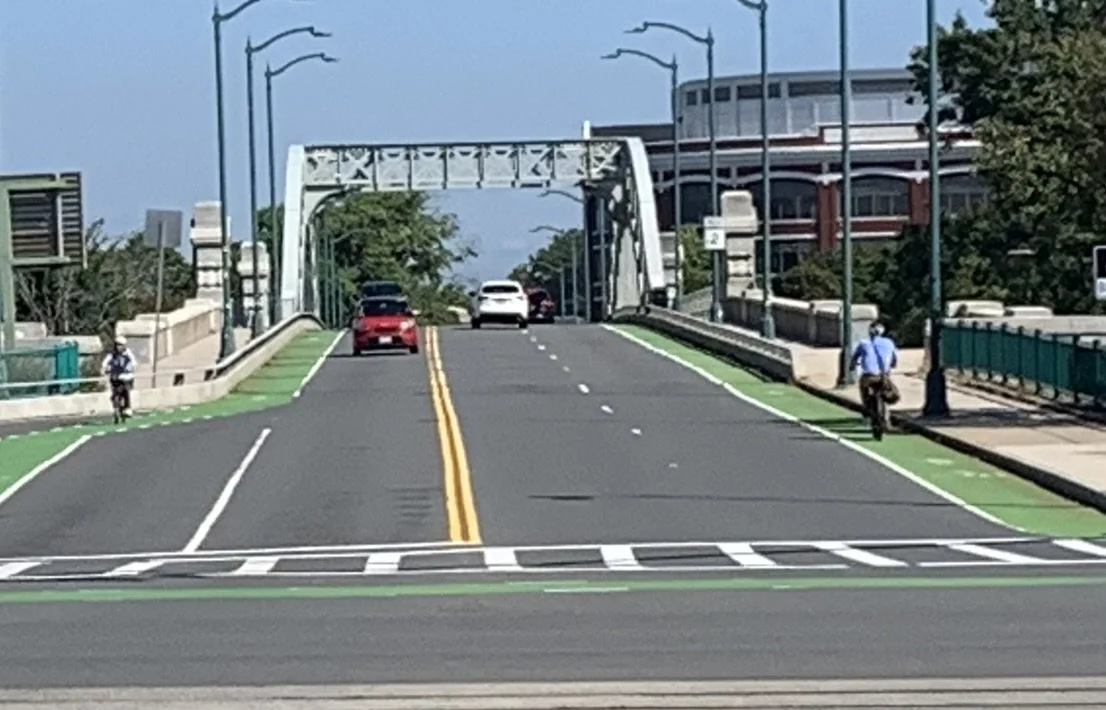
Boston University Bridge Proposed Improvements
The Boston University Bridge serves two MBTA bus routes and carries over 40,000 cars, thousands of pedestrians, and between 1,500 to 2,000 bicyclists a day. Although the bridge has painted bike lanes in each direction, the lanes are next to narrow motor vehicle lanes and are not protected.
In 2023, a group of local residents, safe streets volunteers, and transportation advocacy groups formed the Boston University Safety Alliance to develop proposed quick-build, low-cost changes to the bridge to improve safety and motor vehicle through put. The proposals include protecting the existing bike lanes, widening the sidewalk next to the Memorial Drive eastbound on-ramp to create space for both a two-way bicycle path and a separate area for pedestrians, and moving the bike lane to the curb in the area on the southbound, Boston side of the bridge where it now runs between two motor vehicle lanes.
The Alliance’s proposals are summarized in this document.
In fall, 2023, the Alliance has been presenting its proposals to officials and staff at the governmental agencies that have authority over the bridge. In addition, the Alliance has circulated a petition which we urge you to sign.